Crossing the Atlantic on Maverick
3,000 Miles from Newport, Rhode Island, to Cowes, England, in 18 Days by George Day, Boston Station, Buzzards Bay Post
The first glimpse of the bright flashing light from Sankaty Head lighthouse on Nantucket’s eastern shore came into view soon after midnight. Every seven-and-a-half seconds the white beam swept across the sea that lay between us and the island, giving us a positive visual bearing of where we were in relation to the dangerous shoals than lie all along Nantucket’s southeastern coast. Many ships have foundered here and we did not want to be one of them.
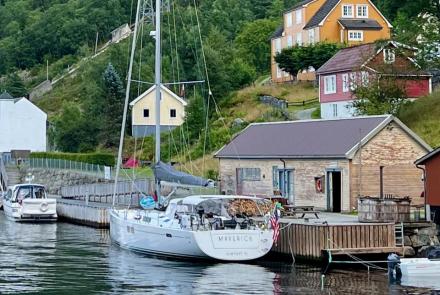
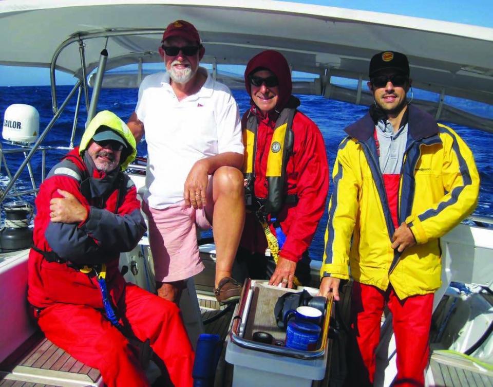
Aboard Maverick, my friend Steve McInnis’s (BOS/NBP) Hanse 505 sloop, we were just getting into the rhythm of our night watches. It was our first night at sea after departing from Newport, Rhode Island, earlier that day. There were five of us aboard: our skipper Steve, Mark Gabrielson, Henry DiPietro, young Drew Augustine, and me. Between us, we had many ocean crossings and offshore passages, so the sense of excitement that always pervades a first night at sea was somewhat tempered by long experience as we settled down and got on with the business of sailing offshore. We still had 3,000 miles to go to our destination in Cowes, Isle of Wight, England.
All the first day we had sailed east across the banks south of Martha’s Vineyard and Nantucket. Fishing boats were dragging their nets all around us, and sea gulls followed them in hopes of a meal. Out there on the continental shelf, two large wind farms have been approved for development, and we saw several survey ships gathering data on depths and bottom configuration. In the years ahead, this whole region of ocean will be populated with giant wind turbines that use only the wind to generate electricity. We are sailors who travel on the wind, so the whole enterprise makes perfect sense.
We cleared the Nantucket Shoals and sailed into deeper water. Late on the first night at sea, the flashing beam of the Sankaty Head light moved farther and farther astern as we sailed east at eight knots. Maverick was sailing fast and steady in the fair southerly breeze. Then, before dawn, we saw the light flash one last time before it sank beneath the western horizon. All was dark except for the moon and stars. We had left land and civilization behind and were now truly at sea.
THE GULF STREAM It took us two days of fast sailing to get to the edge of the continental shelf and to what is known as the western wall of the Gulf Stream. As we sailed east, we saw fewer and fewer shore birds and with every mile, more and more pelagic birds. The shearwaters were everywhere, soaring effortlessly and endlessly over the waves, and flocks of little Mother Carey’s chickens bobbed up and down on the surface.

The water over the continental shelf is a gray-green color, made cool by the threads of the Labrador Current that flow southward along the Canadian Maritimes and northeast U.S. coast. The water is rich with nutrients and thus full of sea life and fish. When you sail across the western wall of the Gulf Stream, the changes to water color and temperature are dramatic. The water turns a perfect sapphire blue and is so clear that you can see right through the tops of waves as though they were made of glass.
Over the course of a few miles as we entered the stream, the water temperature went from the low 60s to the high 70s. We were able to strip off our extra layers of clothing and don shorts and T-shirts for the first time since leaving Newport. We were sailing faster now, as the wind had built to the low twenties and the seas were piling up. There was a large high-pressure system parked in the middle of the Atlantic, called the Atlantic high or Bermuda high, that was generating the stronger southerly winds on its western side. High-pressure systems are usually calm in the middle, while the winds at their edges rotate around the center in a clockwise direction. We were sailing in the western quadrant of the high, so the winds were southerly and brisk. We occasionally saw gusts of 25 to 30 knots.
Plus, we had the current of the stream behind us. The Gulf Stream is a huge river in the Atlantic Ocean that runs from the Florida straits up the U.S. East Coast and then eastward to the Grand Banks and the open Atlantic Ocean, where its name changes and the river become the North Atlantic Current. East of Nantucket, the stream flows at two to three knots in a north-northeasterly direction. But it is not a continuous, uninterrupted river of water in this part of the ocean. It is instead made up of streams and eddies, so you can find yourself with a fair current for a few hours, then no current, and then a contrary current for a few hours. Still, we were seeing a steady boost most of the time, and our speed-made-good was hovering around ten knots.

The stream can be your friend, as it was for us, but it can also be one of the wildest places in the Atlantic Ocean. When deep low-pressure systems move off the U.S coast at Cape Hatteras, as they often do, the counter-clockwise revolving winds will blow from the northeast as the storm tracks to the northeast. This is what creates a nor’easter storm in New England, and what creates mountainous and dangerous seas in the stream. Combine two to three knots of current flowing against a gale of wind, and the results are something no sailor wishes to meet at sea.
For us, the strong southerly breeze was kicking up some waves, but nothing that was disturbing. Maverick is a modern design with a fin keel and large spade rudder. Under the water, the hull is fairly flat and she has a very broad and buoyant transom. This hull shape makes her very fast under sail, but also means that waves running at her from the stern have the effect of lifting the transom. If the waves are from the quarter, as they were for us, then the waves tend to lift the stern and shove it sideways, creating a corkscrewing motion. This made a lot of work for the autopilot that was steering us across the ocean.
Henry had made this passage across the ocean twice before. On our second night out of Newport, he remarked, “The issue with Maverick is not how to get her to sail fast but how to slow her down.”
And that was what we spent our time doing as we rode the Gulf Stream eastward in a strong following wind. We reefed the main and reefed it again, then rolled up some of the roller furling jib. The goal was to keep the speed just under eight knots and to trim the sails so there was no weather or lee helm. This reduced the boat’s sudden corkscrew turns and relieved the pressure on the autopilot. We didn’t intend to steer the boat ourselves very much, and I doubt any of us could steer as consistently and tirelessly as the Jefa autopilot with the B&G control head. Making the autopilot happy made us happy, and we were still making 180-mile daily runs.
THE GRAND BANKS On our fifth day out, the strong southerly breeze abated a bit and came in at 15 knots from the southwest. This was the breeze we expected to ride across the ocean. But, while we had a great day of sailing in fine weather with a warm Gulf Stream current under us, it wasn’t to last. The southern tip of the Grand Banks lay ahead, as did the cold contrary Labrador Current. By midafternoon, we had sailed out of the warm current and into a fog bank. The sea temperature dropped from 73 to 57 degrees in the span of two hours, and we went from shorts and T-shirts to fleece and foul weather gear. Fog and cold are what the Grand Banks are all about, as well as fish and oil. This huge shoal region of banks has played a leading role in the history of the North Atlantic. They were first identified by the Italian explorer John Cabot, who led an English voyage of exploration
in 1497. That the banks were loaded with fish, particularly cod, did not remain a secret for long. Soon, fishing vessels from the north of Spain and Portugal were making the dangerous passage to the banks in search of cod, and the cod fishery continues today.

In its day, salted cod was the one food that could be stored for long periods and thus enabled sailors to make long, slow passages across oceans. It also could be stored ashore all winter and thus provide a ready source of protein when fresh stocks of meat were exhausted. Cod was so important to the life and economy of the Massachusetts Bay colony that a 200-year-old pine carving of a cod hangs in the House of Representatives in the State House, and the speaker faces the cod during meetings. Now that oil has been found on the banks, several fields of oil rigs have been built and pipelines have been run to shore bases in Canada. This has been a boon to the Canadian Maritimes, but it has also increased ship traffic on the already crowded banks, which can be a real navigational challenge for passage-makers like us.
We had initially set our first waypoint at 40° north and 50° west, a point that would be well below the fog and potential for icebergs. But, as we rode the stream eastwards, we could see that there had been no ice reported near the Grand Banks and that the weather was fair. So, we skipped the “40-50” waypoint and sailed straight to the southern tip of the banks. As we passed the tip and sailed across the Labrador Current, we had two days of fog and cold winds. The sea temperature was in the low 50s, and the air temperature about the same.
And then the wind died. We had been riding a good breeze for six days, but on the seventh as we sailed out of the Labrador Current, the wind faded away and we were forced to motor. This, it turned out, was to be our fate all the way across the ocean.
SHIPPING When we passed the southern tip of the banks, we changed course for the English Channel. Our course followed the “great circle” route, which is the shortest distance between two points of a globe. It looks curved on a Mercator projection chart, but is actually a straight line. We soon discovered that we weren’t the only ones who were sailing the great circle route across the North Atlantic.
While still in the fog, we began to see the Automatic Identification System (AIS) signals from ships steaming east and west. AIS is a system that all commercial ships and most offshore yachts now use. It broadcasts a radio signal that is received by all AIS-equipped vessels within 20 miles or so. The signal identifies the vessel and gives course, speed, and other data. When we saw a signal appear on our chartplotters, we could click on it and a box would pop up on the screen that named the ship and gave us all of the ship’s data, including the time and distance of its closest approach to us.
Several times a day, and, it seemed, more often at night, we had ships’ signals active on our chartplotters. The risk of being run down by a ship is any offshore sailor’s greatest fear, since it can happen so quickly that no one would ever know
it happened. AIS almost eliminates the problem, and thus is perhaps one of the greatest boons to safety at sea to come along in the last generation.
Most often, ships pass safely and we rarely had one inside a mile or two from us. But out in the middle of the ocean, a mile does not seem like much of a distance when the ship is a 900- foot bulk-crude carrier.
The wind remained fickle as we sailed and motorsailed across the ocean. We would have light northerlies for a few hours or even a day, and then they would fade. They would be replaced by southerlies that also would not blow for more than a few hours or a day at a time. In between, we burned a lot of diesel and became, like the rest of the ships out there, another motor vessel crossing the Atlantic. The problem was that we didn't have enough fuel to get all the way to England, so sailing as much as possible was the game plan.
On the twelfth day out, as we motorsailed east, we saw two ships seven miles off our port bow. One was a warship that looked like a U.S. destroyer, and one was a Navy supply ship. The two ships were stationary and side by side when we first saw them, then broke apart and steamed their separate ways. Neither of the ships was broadcasting an AIS signal, so we relied on the radar and our visual sighting to keep track of them.

The destroyer steamed off to the east and we surmised that it was on picket duty, probably listening for submarines. The supply ship steamed east for a mile or two and then did something inexplicable. It turned hard to port and laid a course directly toward us. Without AIS, we could not see the time and distance of the closest approach, but we could take bearings on it and could see that we were on a collision course. Way out at sea, close encounters with ships can be unnerving. A close encounter with an American naval vessel had us on edge. There have been two serious collisions caused by U.S. naval vessels in the last year, both with fatalities and both caused by crew errors. Was the ship bearing down on us manned by an alert crew?
When the ship was about a mile away, Steve got on the VHF radio and gave it a call. “Warship, warship, this is the sailing yacht on your starboard bow. We are on a collision course. What are your intentions?”
Soon a reply came in a clear American voice. “Maverick, we see you and will pass across your bow.” That was all he said. We slowed down and the ship did indeed cross our path by a few hundred yards, which we all thought was too close for comfort.
LANDFALL By the time we closed the coast of England and made landfall on the Isles of Scilly off the tip of Cornwall, we were running very low on fuel. We had burned through all nine of the fivegallon jerry jugs that we carried as spare fuel, and all three fuel tanks were nearly empty. The decision was made to head into Falmouth, England, and refuel. Yet this presented a problem, because we didn’t want to dawdle in Falmouth while clearing customs and immigration on a Saturday morning. We wondered if we would be allowed to simply fuel up and go? What if we didn’t mention this to the fuel dock folks?
As we were pondering our strategy, Steve read in a cruising guide to the English Channel that we should call the customs officials by phone as we approached the country. So, using his sat phone, Steve called and got a polite response. We were instructed to photocopy our passports, digitize the files, and email them together with copies of Maverick’s ship’s papers. It was a Friday evening, so we did not expect to have any response from customs until Monday morning. Having traveled to England many times, we all expected the polite customs official to be in the pub by now, having a pint with his mates.
But something remarkable happened. At 9 p.m., we got an email back from the polite customs official. Attached to it was a form that declared that all crew and the U.S.-flagged yacht Maverick were officially cleared into England by both the Home Office’s customs and immigration divisions. We were legal, and didn’t have to skulk our way to a fuel dock after all.

We picked up a mooring in Falmouth late that night. Early next morning we topped up the fuel tanks and set off for Cowes, a day’s sailing up the English Channel. The day was fine, the sun was shining, the sea was a deep blue, and the wind was fair behind us. We got the spinnaker up and sailed east past such famous landmarks as the Eddystone Light, Plymouth, Exmouth, and Dartmouth. The coastline was remarkably undeveloped. Green pastures, hay fields, and cropping lands ran right down to the cliffs above the rocky beaches. There were little villages tucked into the hills and a few great houses, but on the whole England looked ever so much like “that green and pleasant land.”

The wind died as the sun set, so we motored through the night to make our “real” landfall on the Needles that mark the entrance to the Solent and our destination at Cowes. Our last night at sea was clear and bright, with a new moon. The stars were as bright as you ever see them. We had Venus shining in the western sky, Jupiter high overhead, and Saturn and Mars rising in the eastern sky. With these four planets all visible, it was easy to visualize how Earth and her neighboring planets all revolve together around the sun. After 18 days at sea, having lived under the stars, seen the full cycle of the moon and 18 sunrises and sunsets, we all felt as though we were a piece of the big picture, whatever it was.
Dawn saw us enter the Solent. Once more we were close to land, buzzed by motorboats, passed by many sailboats, and stunned by the smells and sounds of civilization. It was all jarring. But, we found a place to moor Maverick in Cowes, got her secured, and wandered ashore to find a proper English breakfast. We all just about stumbled as our legs failed to adjust right away to the inflexibility of terra firma. ✧

ABOUT THE AUTHOR George Day is the founder and publisher of Blue Water Sailing magazine. He also publishes Multihulls Quarterly and the weekly e-newsletters Cruising Compass and Cruising Odyssey. George was an early editor of Cruising World, and after 13 years at the helm of that magazine took five years off to sail around the world with his wife, Rosa, and sons, Simon and Tim, aboard their Mason 43, Clover. The Days live in Middletown, Rhode Island.